The Berlin Mayor and Council have unanimously voted to waive $290 building and fence permit fees for site work and installation of a weather station near Stephen Decatur Middle School.
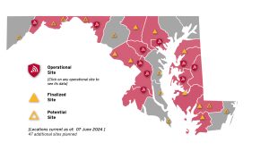
A map shows the designated locations for a network of weather monitoring and data-collection systems across the state planned through the Maryland Mesonet initiative.
Photo courtesy University of Maryland Department of Atmospheric and Oceania Science
By Tara Fischer, Staff Writer
The Berlin Mayor and Council unanimously voted to waive the building and fence permit fees, totaling $290, for site work and installation of a weather station near Stephen Decatur Middle School.
The Maryland Mesonet project, of which the Berlin facility will soon be part, is an initiative that will “design, build, and operate a network of high-quality, closely spaced, rapid-sampling weather monitoring and data-collection systems across the State of Maryland to advance emergency preparedness and commerce.” The expected final product is an observation network.
Lead Environmental Specialist Tyler Pullen of the Maryland Department of Energy Management formally requested that the fee be waived at Monday’s town council meeting. The state-funded project is expected to provide ample data and assistance with agriculture, education, emergency management, utilities, forest management, and tourism decision-making.
MDEM and The University of Maryland have partnered in the forecast initiative. Collected data from each station will be used to better understand the atmosphere and rapidly changing conditions, allowing for quicker public severe storm warnings.
The stations will record temperature, humidity, dew point, wind speed, wind direction, barometric pressure, sunshine, rain intensity, snow depth, and soil conditions.
According to the project outline, in addition to decision-making, the sites will “enhance recovery from storms by identifying and measuring community-level impacts, promote responsible land and water stewardship by monitoring local air and soil, measure weather impacts to critical infrastructure from natural hazards, and provide education and research opportunities for all ages and disciplines.”
Monitoring soil temperature and moisture will equip the agriculture industry, data will benefit education in making school closure decisions, accurate forecasts will aid the tourism sector, and information on precipitation and wind will help individuals with transportation planning.
Each site was selected based on set criteria. The area’s representation of the local area and the lack of outside forces that may impose bias or inaccurate data, like unnatural bodies of water or large concrete areas, were determining factors.