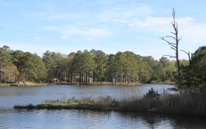
Herring Creek is one of many local waterways being monitored by Assateague Coastal Trust. The group encourages people to use three apps, Swim Guide, Water Reporter and MyCoastMaryland that provide information on water quality and safety and help members of the community become citizen scientists.
By Cindy Hoffman, Staff Writer
(April 27, 2023) Many people who move to the Eastern Shore do so to be close to the water. The region provides plenty of opportunities and places to enjoy the water, through boating, swimming, fishing and dining at one of the many waterfront restaurants.
But for people to enjoy all of these opportunities, the water needs to be clean and safe. There are three apps that provide information on water quality and safety and help members of the community become citizen scientists by easily recording and sharing data on water and pollution events.
The apps are Swim Guide, Water Reporter and MyCoastMaryland. Each of the apps can be easily downloaded to a mobile phone. The apps provide information on water conditions in the area and the opportunity to provide data and observations.
“We want people to get familiar with these apps. They are easy to use tools that aid in scientific research and enforcement,” Gabby Ross, a coastkeeper for Assateague Coastal Trust (ACT) said.
“By using these apps, we can protect our coastal way of life,” Ross said.
ACT submits data on enterococcus bacteria levels weekly to the Swim Guide App from 11 sites along Isle of Wight Bay, Assawoman Bay, St. Martin River, Shingle Landing Prong, Herring Creek and Turville Creek.
New data from the region is available every Friday.
“Enterococcus bacteria comes from many sources, but is typically associated with fecal matter. Failing septic tanks, failing wastewater treatment plants and geese and other waterfowl feces.
“We have mostly brackish water here, which is where enterococcus thrives,” Ross said.
By using Swim Guide, water sport enthusiasts can know the quality of water before they jump in.
“Swim Guide makes it really easy, you have green, yellow and red, same thing as a stoplight. Green means you are good to go. Yellow means be cautious, especially with the weather, and red is obviously, it failed for the week, use extreme caution,” Ross said.
“Generally speaking, with enterococcus bacteria, you never want to be swimming with open cuts or wounds. It could get into the bloodstream and cause an infection.”
“Always monitor the weather, you never want to swim in an area that could be yellow or red, especially after a heavy rainfall,” Ross said, explaining that the enterococcus bacteria is usually higher after a rainfall. She suggests waiting 48 hours after a major rain event to get in the water.
Swim Guide is not just for experts. People can become citizen scientists by downloading the app and reporting pollution events they see while they are out on the water.
Ross encourages the reporting of fish or aquatic life high mortality events, sewage overflows, foul-smelling water, algae blooms or weird colored foam, oil spills or other contaminants that create a sheen in the water, large amounts of sediment, or strange colored water.
“If you are not sure, document it anyway. It’s better to document and let someone know about it. The further you let it go, the worse it could get,” Ross said.
The app is easy to use, just download it onto your phone and when you see an event, report it. The app accepts date, time, weather, the exact location, photos, and detailed comments.
Ross had her own experience driving through Ocean City once. She saw some kind of solvent being released into the waterways at the Ocean City convention center. It turned out to be a floor cleaner that one of the workers dumped. She was able to report the spill to Ocean City Public Works and the liquid was cleaned up immediately and the workers were educated on the need to properly dispose of these chemicals.
“If you see something, say something,” Ross said.
All events in the area go directly to Ross, so she can investigate the pollution event and notify appropriate authorities.
“We are the ears, eyes and nose for the waterways,” Ross said.
“We want people to be communicating about these types of events because the more people know about it, the more awareness builds and the better off we all are on the coastal bays watershed.” Ross said.
A second app, Water Reporter, is more of a social network to support watershed initiatives. This app is used for stream restoration and for those who are involved in the waterways or want to connect to people who are working on these issues.
People can follow other people and groups. Ross encourages people to follow here at Gabby Ross and Assateague Coastal Trust.
For Water Reporter, ACT submits everything they see, including bacteria, dissolved oxygen, water temperature, pH levels, and pollution events.
“A lot of waterkeepers are using this,” Ross said.
“Government agencies are using these apps to collect information and they are also using it for legislation, grants or funding opportunities for different waterways.
“It can also help you find waterways that you might not have explored yet.”
The Water Reporter app helps organizations monitor areas they cannot get to by accessing information from citizen scientists.
“We can turn these reports into action,” Ross said.
A third app, MyCoastMaryland is used to document flooding statewide. Residents are familiar with the regular flooding in the low lying areas of downtown Ocean City. Many Ocean Pines residents experience regular flooding during heavy rains along canals and some of the lower lying areas in the community.
“Through MyCoast, we can help you tell your story,” said Kate Vogel, a coastal resilience planner for Maryland DNR.
On average, high tide flooding days are expected to increase.
“The knowledge we are gaining from communities helps with resilience planning,” Vogel said.
“The app can help property owners, business managers, local government and decision makers determine where flooding is happening,” Vogel said.
The app is used to track high tide flooding, storm reporting, coastal storm damage and restoration efforts.
This knowledge we are gaining from communities, we can incorporate into our planning for the future,” Vogel said
By tracking the flooding data, DNR can identify areas that need grant money for projects such as green infrastructure.
“We can’t get the necessary dollars if we don’t have this data collected. We all have a common goal, to prevent the eastern shore from being left behind.
“All of these apps are going to make a better Maryland,” Ross said.