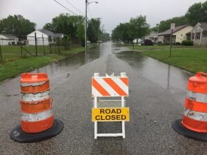
SUBMITTED PHOTO
About half a dozen streets in Berlin were closed last Thursday because of heavy rains. Some streets elsewhere in the county, including in Snow Hill, were closed up until early Tuesday morning.
By Josh Davis and Brian Gilliland, Associate Editors
(May 24, 2018) Heavy rains last week wreaked havoc across Worcester County, causing street closures lasting into the early part of this week and necessitating several police rescues.
Flood warnings remained in effect through Tuesday morning, according to the law enforcement agencies throughout the county.
Many roads remained closed during the early part of the week, including Route 12 at the drawbridge in Snow Hill, Whiton Crossing, Purnell Crossing, Porters Crossing and Nassawango Road, and Dividing Creek Road.
“The water levels are subsiding a little, but remain high enough to prevent vehicles from navigating through them,” the sheriff’s office said in a Monday Facebook post. “We are hopeful that the water levels will continue to drop over the next 48 hours.”
Bill Sammler, warning coordination meteorologist with the National Weather Service, said Worcester County saw 3-5 inches of rain, with the Ocean City Airport reporting 5.47 inches since last Monday.
Nearby Salisbury has had 8.52 inches of rain so far this month, good enough for the third-wettest May since 1906, Sammler said.
In Berlin, Police Chief Arnold Downing said no injuries were reported, but that several drivers stranded in inoperable vehicles called for police help last week.
According to a press release on Friday, “The Berlin Police Department assisted several motorists that were trapped in today’s weather. Many of Berlin’s streets had to be closed due to the heavy rains and flooding.”
Streets closed included West Street, Franklin Avenue, Branch Street, Bay Street, Flower Street, Buckingham Road, Powell Circle, and William Street.
Police said rescues began around 10:15 a.m. Friday and lasted several hours. Officers in Berlin used the department’s five-ton military surplus truck during the deluge.
“One of the rescues involved a handicapped person who was driven home by the officer. Three vehicles were left inoperable and had to be towed away,” Berlin Police said.
Ocean Pines Police Chief David Massey said there were no calls for help in the community, “Just some low-level flooding in a few areas.”
State police last Thursday urged caution on social media with a “Turn Around, Don’t Drown” campaign.
“According to the National Oceanic and Atmospheric Administration, it takes just 12 inches of rushing water to strand a small vehicle, while 24 inches of fast flowing water can carry away most vehicles,” state police said, also citing the Centers for Disease Control and Prevention as reporting more than half of flood-related deaths occur when a vehicle is driven into hazardous flood water.
As for forecasts during the Memorial Day weekend, meteorologist Tony Pann from WBAL said additional rain was “tied to what may or may not happen in the Gulf of Mexico.”
“Many of the computer models have some sort of tropical system developing in the gulf and, at the same time, an area of high pressure off the East Coast,” Pann said. “This combination may end up funneling tropical moisture into the Mid-Atlantic.
“The most likely days for rain this weekend will be on Sunday and Monday,” he continued. “This basic atmospheric set up, a storm in the gulf and high pressure east of Maryland, was also the main reason for all of the rain the last several days. The pattern was just locked in, but that does not seem to be the case again early next week.”
